Article: Should You Buy a Marine GPS or Chartplotter?
Should You Buy a Marine GPS or Chartplotter?
A wrong turn on the road may cost a few minutes. A wrong turn on open water can put you in shallow water, outside a marked channel, or back at the dock after dark without a clear route home. That is why choosing a marine GPS or chartplotter deserves more thought than simply picking the biggest screen that fits your console.
Both tools can help you know where you are, save productive fishing spots, and travel with greater confidence. The difference is in how much navigational context they give you and how you plan to use your boat. For a simple skiff on a familiar lake, a basic GPS may be all you need. For coastal cruising, offshore fishing, or regularly boating in unfamiliar waters, a chartplotter can become one of the most valuable electronics aboard.
Marine GPS or Chartplotter: What Is the Difference?
A marine GPS receiver determines your position using satellite signals. Depending on the unit, it may display latitude and longitude, speed, direction of travel, waypoints, routes, and distance to a destination. Think of it as the device that answers the essential question: Where am I?
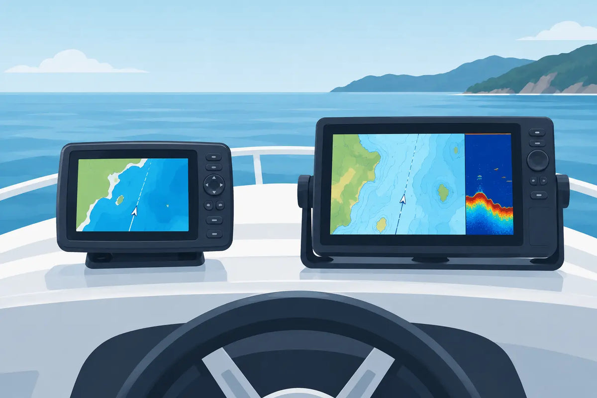
A chartplotter also uses GPS, but pairs that location data with detailed electronic nautical charts. Rather than seeing only coordinates or a basic route line, you can see your boat position in relation to shorelines, channels, buoys, marinas, depth contours, hazards, and other charted features. It answers a more useful boating question: Where am I, and what is around me?
The terms are sometimes used interchangeably because many modern chartplotters include full GPS capability. Still, the distinction matters when comparing models. A handheld GPS can be an excellent navigation backup or an affordable solution for straightforward use. A chartplotter is typically a fixed-mount system built for a helm, with a larger display and more integration options.
When a Basic Marine GPS Makes Sense
A dedicated marine GPS is a practical choice for boaters who want dependable position information without adding a complex electronics system. It works especially well on smaller boats, tenders, canoes, kayaks, and simple fishing rigs where dash space and budget are limited.
If you primarily use familiar inland lakes or rivers, you may only need to mark the boat ramp, favorite coves, safe passages, and fishing locations. A compact GPS can save these waypoints and guide you back to them. It can also provide useful speed-over-ground readings for anglers dialing in a trolling motor pace or boaters watching their travel time.
Portability is another advantage. Handheld units can move from boat to boat, go ashore with you, and serve as a backup if a fixed electronics display loses power. Models designed for marine use are generally built to tolerate water exposure and bright sunlight better than a phone.
The trade-off is situational awareness. A GPS that shows your coordinates and a directional arrow does not replace a detailed chart. You still need to understand the waterway, observe markers, maintain a proper lookout, and carry the appropriate paper charts where they are required or sensible. Electronics support sound seamanship; they do not replace it.
Why Many Boaters Choose a Chartplotter
For boaters venturing beyond a familiar shoreline, a chartplotter provides a clearer picture of the route ahead. Detailed charts can show navigation aids, shoaling areas, channel boundaries, bridge clearances, marina locations, restricted areas, and contour lines. That added context is helpful when weather changes, daylight fades, or you need to alter your course.
A chartplotter also makes route planning easier. You can create waypoints, build routes between them, monitor your track, and retrace a safe path after a day of fishing or exploring. On a larger lake, a busy river, or coastal water, that record of where you have been can be reassuring.
Many units also become the central display for other onboard information. Depending on the model and compatible equipment, a chartplotter may connect with sonar, radar, VHF radio, engine data, an autopilot, AIS traffic information, and wireless devices. This does not mean every boater needs every feature. It does mean you can choose a system that fits your boat now while leaving room to grow.
For anglers, a chartplotter paired with a fish finder is often the most compelling combination. Lake maps and depth contours help identify likely structure, while sonar helps confirm what is below the boat. Saving waypoints for brush piles, drop-offs, reefs, and productive trolling passes is much easier when your navigation and fishing information are on the same display.
Chart Quality Matters as Much as the Screen
Not all chart coverage offers the same detail. Before choosing a unit, confirm that the included or available charts cover the waters you use and provide the level of detail you expect. Inland lake mapping, coastal charts, and offshore coverage can vary by brand, region, and subscription or update options.
A large screen cannot make incomplete chart data more useful. If you cruise the Intracoastal Waterway, fish coastal bays, or travel between unfamiliar lakes, chart coverage should be a priority in your decision. Regular updates are also worth considering, particularly in areas where channels, hazards, and marina information can change.
Choosing the Right Screen Size and Mounting Location
Screen size affects comfort and safety. A display that looks generous in a showroom can feel small when you are standing at the helm in direct sun, wearing polarized sunglasses, and trying to monitor a route while watching the water.
For a compact center console, pontoon, or aluminum fishing boat, a 7-inch display is often a sensible starting point. It can provide clear charts and sonar without overwhelming the dash. An 8- to 10-inch screen offers more room for split-screen viewing, such as charts on one side and sonar on the other. Larger displays are especially useful on cruisers, offshore boats, and vessels with enough helm space to view multiple data sources comfortably.
Mounting deserves equal attention. The unit should be easy to see without blocking gauges or requiring you to turn away from the water for too long. Flush mounting offers a clean, built-in look, while a gimbal or bracket mount can make it easier to adjust the viewing angle. On open boats, make sure the display, connectors, and mounting hardware are rated for the marine environment.
Look Beyond the Display
A chartplotter is only as dependable as its installation. Proper power connections, fusing, cable routing, antenna placement, and secure mounting all affect performance. If your boat is older or has limited helm space, it may be wise to speak with a knowledgeable marine electronics professional before selecting a larger networked system.
Also consider how you prefer to operate the unit. Touchscreen controls feel familiar and are quick for panning charts, but physical buttons can be easier to use in rough water, rain, or cold conditions. Some models offer both. There is no single best choice - the right interface is the one you can use confidently while keeping your attention on the water.
Features Worth Paying For, and Features You May Not Need
Start with the waters you boat, not a checklist of impressive specifications. GPS accuracy, a bright sunlight-readable screen, reliable chart coverage, easy waypoint management, and a durable waterproof rating are foundational features for nearly every boater.
Sonar capability is worthwhile for anglers and for boaters who want more awareness of depth changes beneath the hull. Side-scan and forward-looking sonar can be valuable in the right setting, but they are not necessities for every weekend cruiser. Radar can add meaningful awareness in fog, rain, darkness, and congested coastal traffic, while AIS information can be especially useful around commercial vessels. These features involve added equipment, installation, and learning time, so they should match the kind of boating you actually do.
Networking is another practical consideration. If you expect to add a VHF radio, radar, engine monitoring, or autopilot later, select a chartplotter with compatible connections from the beginning. Buying for future expansion can be smart, but paying for advanced networking on a small boat that will never use it is not always the best value.
Do Not Rely on a Phone as Your Only Navigation Plan
A smartphone with a navigation app is a useful companion, particularly for checking weather, reviewing routes, or carrying an extra set of charts. But it is not an ideal primary navigation system for many boaters. Battery life, screen glare, overheating, cellular coverage, water exposure, and mounting security all become real limitations on the water.
A purpose-built marine GPS or chartplotter is designed for the environment where you need it most. It can remain powered by the boat, stay visible in sunlight, and provide navigation information without relying on a cell signal. Carrying a phone and a paper-chart backup remains wise, especially on longer trips, but a dedicated marine unit offers more confidence at the helm.
Make the Purchase Fit Your Boating Life
The best navigation electronics are not necessarily the most expensive or feature-packed. They are the ones that make your time on the water easier, safer, and more enjoyable. A portable GPS may be the right answer for a paddler or a casual lake angler. A chartplotter with detailed mapping and sonar may be a better long-term fit for a family pontoon, a fishing boat, or a coastal cruiser.
At Open Air Lifestyles, real customer support can help take the guesswork out of a higher-ticket marine electronics purchase. Choosing from authorized products with manufacturer warranty coverage gives you a clearer path to dependable use long after installation day.
Before your next outing, picture the water you want to explore rather than the screen you want to own. The right navigation tool should help you leave the dock with confidence, spend more time enjoying the ride, and return with an easy route home.